Residents of Chipwi District in northern Kachin State are concerned that landslides along the road between Waingmaw and Chipwi towns caused by heavy rain will lead to transport disruptions and shortages.
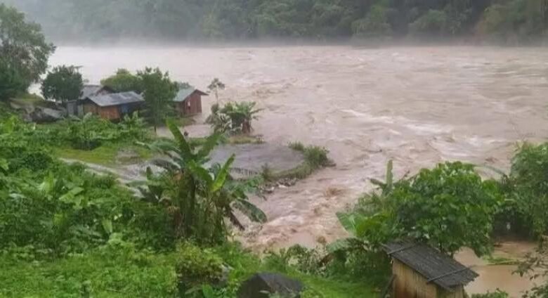
Since 23 May 2025, heavy rain has pounded the towns of Chipwi, Pang War, and Tsawlaw in Chipwi District. It has caused flooding that has inundated homes and internally displaced persons (IDP) camps and caused some casualties.
As a direct consequence of the heavy rains, major landslides have occurred in three sections along the Waingmaw Town to Chipwi Town Road, rendering it impassable for large trucks. At present, only small passenger vehicles and motorcycles are able to use the route.
Part of a detour that shortens the journey, which is only normally passable by cars, motorcycles and pedestrians, has also become submerged. To get past the submerged section travellers have to use bamboo rafts. The raft operators are charging pedestrians 5,000MMK and motorcycles 10,000MMK to get them across the flooded section.
Another key supply route to Chipwi Town blocked by flooding is the road between Chipwi Town and Pang War Town, a border crossing town that acts as an entry point for imports from China. This has led to scarce availability of certain goods in Chipwi Town.
During the 2024 rainy season Chipwi Town was also affected by flooding. But, this year, the N Mai Kha River, that flows past Chipwi Town, has risen and submerged communities faster than other years. As a result, flood affected residents of the town already need food and other aid.
A woman living in Chipwi Town said: “We thought that since there was already a big flood last year, this year wouldn’t be as bad. So, we only stockpiled food for two or three days. In the IDP camps, most of the food stored was kept up in the lofts. Last year, even though the flooding was serious, the water didn’t reach the roof. But this time, the flood was worse than we expected—it swept away all the food we had stored. Now, everyone’s really struggling and in urgent need of basic food staples.”
After the N Mai Kha River, flows past Chipwi Town it joins with the Mali Kha River about 50 miles (80 km) downstream, to form the Ayeyarwady River about 25 miles (about 40km) north of Myitkyina City, the Kachin State capital.
At about 7:30 am on 2 June 2025 in Myitkyina City, due to high water levels in the N Mai Kha and Mali Kha rivers, the water level of the Ayeyarwady River peaked at 1,205 cm, 5cm above the danger depth of 12 metres.
This led to the flooding of low-lying wards in Myitkyina City, including the wards of Kachinsu, Kyatpaungchan, Ranpu, Lelkone, Pawoo, Myothitgyi and Sitarpu Ward, where the waters flooded the landmark Manau Square, where the traditional Kachin Manau dance is performed on occasions that are important to the Kachin.
But, since 3 June the level of the Ayeyarwady River in Myitkyina has been going down at an average speed of about 5cm an hour.
Last year, on 30 June 2024, the water level of the Ayeyarwady River reached a depth of 14 metres and 6cm, more than 2 metres above the danger level. On that occasion several low lying Myitkyina City wards were also flooded.


